
Fort Dupont, Delaware Parade Ground, courtesy of Wikipedia.
Fort DuPont, Delaware, on the western shore of the Delaware River, south of Delaware City in New Castle County, was commissioned in 1898. Located between the original Delaware City and the modern Chesapeake and Delaware Canal, Fort Dupont was named for Rear Admiral Samuel Francis Du Pont, a Civil War Naval Hero. Along with two other forts of the Harbor Defenses of the Delaware, it defended the Delaware River and the water approach to Philadelphia, Pennsylvania, from 1900 through 1942. Deactivated in 1946, the site is a state park today.

Delaware River view in New Castle County, Delaware. Photo by Carol Highsmith.
The first fortification was built from 1863 to 1864 on property the government bought from 1st Lieutenant Clement Reeves of the 5th Delaware Volunteer Infantry. Briefly called Fort Reynolds, it was a ten-gun battery, an auxiliary to nearby Fort Delaware.
During the Civil War, the fort was part of a system of forts overlooking and protecting the capital city of Washington, D.C. It had six sides, each 100 feet long, protected by a deep moat and trees felled side-by-side with branches pointing outward. It was named for Flag Officer Samuel F. Dupont, who commanded the naval victory at Port Royal, South Carolina, in November 1861.
Although its garrison and guns never saw battle, Fort Dupont served as a lifeline of freedom. Runaway slaves found safety here before moving on to join the growing community of “contrabands” in Washington.
In 1870, the federal government purchased 66 acres from Clement Reeves on the western side of Ten Gun Battery, and a permanent military post was established on the Delaware shore. This tract of land housed a 20-gun Battery to house heavy guns and coast defense mortars, but it was not fully armed. The first soldiers to garrison the post were from Captain John Jay Young’s Independent Battery G, also called the Pittsburgh Heavy Artillery.
“This fortification is not properly a Fort but rather a water battery. It has five sides across the river from Fort Delaware on the Delaware City side. The two longest sides next to the river is a heavy breastwork on which six 10-inch and four 15-inch Rodman guns are mounted.”
— Sergeant. Bishop Crumrine of Young’s Battery
In 1876, a mine casemate was built for an underwater minefield.
In 1885, the Board of Fortifications made sweeping recommendations for new coast defenses. Most of these recommendations were adopted in what became known as the Endicott program. Before the Spanish-American War and continuing in the following few years, major construction took place to upgrade the defense capabilities of the three forts defending the significant ports along the Delaware River.
Outdated guns were removed in 1897 to facilitate the construction of modern masonry fortifications, replacing the Ten Gun and Twenty-Gun Batteries. The Endicott Board recognized the need for a coastal defense system that matched the firepower of world navies. These concrete batteries served to protect gun crews and store ammunition, while their substantial weight and recoil required solid mounting platforms. Earth or sand provided additional protection against naval assaults. The installation of eight- and twelve-inch steel guns on disappearing carriages in these fortifications offered the best defense for the nation’s coast.
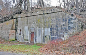
Mine Control Casemate at Fort Dupont, Delaware, courtesy of Wikipedia.
In 1898, the site was formally commissioned as Fort DuPont in honor of Rear Admiral Samuel Francis Du Pont as part of the nation’s coastal defense system. Commissioned under the recommendations of the Endicott Board, it was constructed in the open-plan design of a well-ordered military landscape. Like other open-plan forts, batteries were placed on the side of the fort susceptible to military bombardment, on the east side of the river. In the subsequent years, Fort DuPont became the chief protector of Wilmington and Philadelphia.
Construction began in 1899, and the new fortifications were completed in 1902. These included two eight-inch and 12-inch breech-loading rifles and 16 twelve-inch breech-loading mortars. Completing the concrete gun and mortar emplacements with their armaments installed was only the first step in completing Fort DuPont as a coastal fort of the Endicott period.
Soldiers of the 4th U.S. Artillery garrisoned the post under the command of Major Van Arsdale Andruss. Fort DuPont included the headquarters for the three-fort complex and had more barracks and administrative buildings than the other two forts. In 1901, the heavy artillery companies garrisoning forts were redesignated as coast artillery companies under the Artillery Corps.
After 1902, more land was acquired to construct permanent buildings and supporting facilities.
On completion, Forts DuPont, Delaware, and Mott were an artillery district, redesignated in 1913 as the “Coast Defenses of Delaware.”
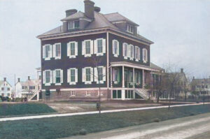
Fort Dupont, Delaware Hospital, about 1920.
Fort DuPont’s construction, including residences, schools, barracks, and support structures, was primarily completed by 1915. Orderly roads defined the reservation’s layout, with ancillary buildings surrounding the artillery batteries and various facilities lining the roads. A significant parade ground, situated between the west and east buildings, became the fort’s focal point, featuring a commemorative flagpole that marked it as the heart of the base.
Additional improvements to Fort Delaware on Pea Patch Island consisted of installing three 12-inch disappearing guns. Fort Mott, near Finn’s Point on the New Jersey shore, also became a significant battery with three 12-inch disappearing guns.
During World War I, Fort DuPont continued to serve as a coastal defense post, a training post for local draftees, and a deployment site for artillery units. In 1915, Batteries Read and Gibson were declared obsolete.
Following the war, Fort DuPont transitioned to a quartermaster depot and became an engineer post with the arrival of the First Engineers in May 1922. During this time, Battery E, 7th Coast Artillery, was the caretaker detachment for the Coast Artillery Corps facilities at Fort DuPont and the other Delaware River forts.
Fort Saulsbury, near Slaughter Beach, Delaware, was built in 1917-1920 and accepted for service in 1924. It effectively replaced the three forts near Delaware City, though these retained mortars, mines, and some guns through early World War II.
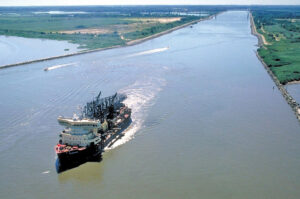
Chesapeake and Delaware Canal, Delaware City, courtesy of the American Society of Civil Engineers.
When the U.S. Army Corps of Engineers purchased the Chesapeake and Delaware Canal in 1919 for $2.5 million, the canal-side lane and lockkeeper’s house were incorporated into the fort’s planned landscape. The Wingate House, which is no longer standing, became part of the officers’ residential area, and the tree-lined lane was joined to the fort’s road system.
In the 1930s, the Works Progress Administration constructed a theater that still stands today, bordering the parade ground. Additional non-commissioned officers’ quarters filled the recently reclaimed wetlands to the north and east of the fort’s central axis. Buildings for the storage and repair of bridge pontoons filled the open fields west of the batteries.
On December 12, 1932, six sets of officers’ quarters were floated to Fort DuPont from Fort Mott in Pennsville, New Jersey. One set of quarters was floated over the year before. From 1934 until 1936, Fort DuPont and the 1st Engineer Regiment were commanded by Colonel Ulysses S. Grant III, grandson of President Ulysses S. Grant.
During World War II, Fort DuPont served as a mobilization station for deploying units and contained a prisoner-of-war camp for captured German soldiers and sailors. At that time, about 300 buildings and structures lined the streets of Fort DuPont.

A German POW Camp in Delaware during World War II.
In 1942, the headquarters for the Harbor Defenses of the Delaware were transferred, along with artillery troops, to Fort Miles in Lewes, Delaware. By this time, Fort DuPont was disarmed, and all weapons scrapped, as Fort Miles had superseded the previous defenses of the Delaware.
In May 1944, a prisoner-of-war camp was established using repurposed temporary buildings in the mobilization area. During the war, roughly 3,000 German POWs were housed at Fort DuPont. These included crew members of the submarine U-858 that surrendered off the coast of Lewes, Delaware, along with the rest of the German forces in May 1945. The prisoners worked as dishwashers, waiters, grocers, butchers, and other support roles on the post and other local installations such as the New Castle Army Air Base. German POWs worked for civilian canneries and garbage companies and repaired boardwalk sections for Rehoboth Beach.
Following the war, effective December 31, 1945, Fort DuPont was declared surplus and offered to the Veterans Administration as a veterans hospital. After they declined, the state bought the site at a 100% discount and adapted existing structures for reuse.
In 1947, Fort DuPont was turned over to the State of Delaware, and the state tore down the temporary mobilization barracks before the health center opened. The mobilization hospital complex, recreation hall, and chapel were integrated into the health center’s master plan. In 1948, the post reopened as the Governor Bacon Health Center, operated by the Delaware Division of Health and Social Services.

Officer’s Row at Fort Dupont, Delaware, about 1920.
In 1976, the Major General Joseph J. Scannell Armory was built on the site of the former POW camp.
By 1980, most of the quarters on Officers Row had been cannibalized and demolished. Sections of Fort DuPont are governed by six different state agencies, which often leads to confusion over who is responsible for maintaining specific roads, buildings, and structures.
In 1992, a large portion was rededicated as Fort DuPont State Park. By 1996, over 300 acres had been reestablished at the park.
In 1996, the Major General Joseph J. Scannell Armory became the home station for the 153rd Military Police Company, a unit in the Delaware Army National Guard.
The site was officially designated the Fort DuPont Historic District in 1999 after being listed in the National Register of Historic Places. It includes Fort DuPont State Park and the Governor Bacon Health Center, covering about 350 acres and over 75 buildings, structures, and objects.
By 2011, fewer than 80 historic buildings and structures remained.
In 2016, the acreage not in the state park system was annexed into Delaware City.
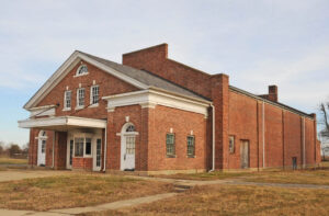
The old theater at Fort DuPont, Delaware, courtesy of Wikipedia.
Today, the Fort DuPont Historic District consists of 305 acres on the west side of the Delaware River, containing 101 resources, including buildings, structures, objects, and sites.
The park’s unique location at the mouth of the Chesapeake & Delaware Canal and the Delaware River positions it perfectly for fishing and launching vessels. The 1.1-mile River View Trail, with a packed earth surface, travels through tidal marsh, past gun batteries, and offers a glimpse into Delaware history.
©Kathy Alexander/Legends of America, updated August 2025.
Also See:
Forts Across the United States
Forts & Presidios Photo Gallery
Soldiers & Officers in American History
Sources:
Delaware State Parks
Fort DePont
National Park Service
National Register of Historic Places
Wikipedia