
Stephen Watts Kearney,
In 1848, Colonel Stephen W. Kearney laid out a trail from Fort Leavenworth, Kansas, to the junction of the Independence Road and the St. Joe Road west of the Big Blue River. That same year, Fort Kearny, Nebraska, was established, and this trail became part of the Fort Leavenworth-Fort Kearny Military Road. Fort Leavenworth was destined to supply a sizable percentage of westward traffic as the principal U.S. Army base on the Missouri River. The road angled northwestward from the fort to Eight Mile House, where the connecting road to Fort Riley, Kansas, and the Santa Fe Trail broke off.
A year later, surveyor and civil engineer Captain Howard Stansbury was sent to explore and survey the Great Salt Lake. Captain Stansbury and 18 men, five wagons, and 46 horses and mules left Fort Leavenworth along the same trail as Colonel Stephen W. Kearney in May. For some distance, the path followed the Oregon-California Trail from St. Joseph, Missouri, by way of the Blue River. Stansbury described the trail as “already broad and well-beaten as any turnpike in our country.”
Near Marysville, the trail crossed the Big Blue River and joined the Oregon Trail, following the Little Blue River as far as possible toward Fort Kearny, Nebraska.
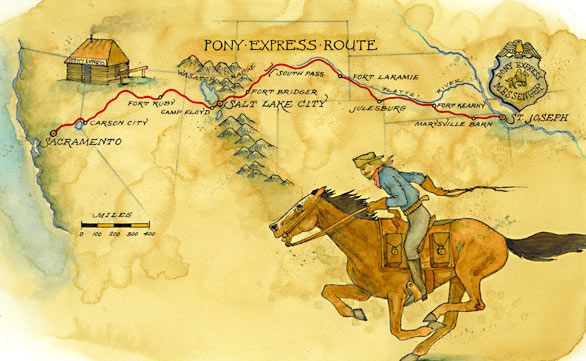
Pony Express Route
In 1849-1850, Brigham Young led thousands of exiled Mormons across portions of the same trail. Two years later, the old military road was lined with emigrants and gold seekers. It finally became one of the country’s most crucial stage and freight wagon roads. On April 3, 1860, the Pony Express began to use parts of the old military road. It eventually became one road with many names — The St. Joe to California branch of the Oregon Trail, The Pony Express route, and the Overland Road to California.
©Kathy Alexander/Legends of America, updated February 2025.
Also See: