
Rio Grande in Boquillas Canyon in Big Bend National Park in Texas. Photo Courtesy of the National Park Service.
The Río Grande is an essential source of water for the American Southwest. At nearly 2,000 miles long, it is the fourth-longest river in the continental United States.
Also known as the Río Bravo, El Río Bravo del Norte, and the Río, it was crucial to settlers migrating to and establishing homes in the west, as well as for the expansion of the railroad. The river’s flow was utilized extensively, and once the stream itself was appropriated, many water users turned to the connected aquifers and groundwater resources for their water needs.
The river supports more than six million people, including numerous Pueblo and Tribal Nations, cities and towns, agriculture, communal irrigation systems, and countless wildlife species and ecosystems. Along the length of the Rio, communities rely on the river and its tributaries as an essential cultural resource and for drinking water, agriculture, flood control, power generation, municipal uses, abundant recreation, and as a habitat for birds. It is the backbone of local economies.
The Rio Grande rises in the western part of the Rio Grande National Forest, in the snow-capped peaks of southern Colorado’s San Juan Mountains, and traverses 1,896 miles of desert and canyon before joining the waters of the Gulf of Mexico. The river is formed by the joining of several streams at the base of Canby Mountain, due east of the Continental Divide of the Americas. From there, the Rio Grande flows east and south through the agriculturally rich San Luis Valley, then south into New Mexico, passing through the Rio Grande Gorge near Taos, and continuing toward Española. It subsequently collects additional water from the Colorado River basin and the Rio Chama.

Rio Grand National Forest, courtesy of Recreation.gov.
Continuing southward, the river irrigates the farmlands in the Middle Rio Grande Valley through the desert cities of Albuquerque and Las Cruces, New Mexico. In the Albuquerque metropolitan area, the Rio Grande flows by historic Pueblo villages, such as Sandia Pueblo and Isleta Pueblo. From there, it moves to El Paso, Texas, then forms the border with Mexico as it flows east through Big Bend National Park. By the time the Rio Grande leaves El Paso, so much water has been diverted that the riverbed between the cities of El Paso and Presidio, Texas, is often dry.
The river finally reaches its terminus at the Gulf of Mexico, just east of Brownsville, Texas.
The segment of the Rio Grande that forms the international border measures between 889 and 1,248 miles, depending on how it is measured. The Rio Conchos, a significant tributary of the Rio Grande, converges with the river 193 straight air miles southeast of El Paso, near Ojinaga in Chihuahua, Mexico. Further downstream, other tributaries such as the Pecos River and the Devils River flow into the Rio Grande from the north, near the Amistad Reservoir in Texas. Additionally, the Rio Salado and the Rio San Juan enter from the south, with their confluences located in Tamaulipas, Mexico. It is important to note that Big Bend National Park’s jurisdiction extends only to the middle of the deepest part of the river channel; the remaining areas of the river lie within the Republic of Mexico.
For over a million years, the Rio Grande’s flow was dictated solely by the rhythms of snow and rain, as well as the seasonal shifts between winter and summer. Sometimes, it surged—flooding its banks and ushering sediment downstream. In other years, it whispered its winding way across the landscape.
Before humans subdued it, the Rio Grande ran wild. Its dynamic flows shaped a unique and extensive riparian corridor through the desert Southwest, carving geologic features like the 50-mile-long Rio Grande Gorge in northern New Mexico and the 1,500-foot walls of Santa Elena and Mariscal Canyons provide much of the scenery amidst a remote, rugged wilderness, Although water sources are abundant throughout the landscape and flash floods occur after heavy rains, the Rio Grande remains the park’s most prominent source of water.
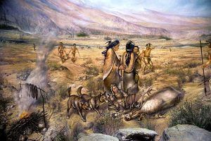
Paleo Indian People.
The archaeological record of prehistoric occupation of the Rio Grande area is as long as it is elsewhere in the Southwest. Sites dating back to the Paleo-Indian Period, from approximately 11,000 to 7,000 B.C., are known through excavation and reconnaissance surveys.
Archeological sites from the earliest human presence in the Rio Grande Valley are scarce due to traditional Indigenous nomadic culture, river erosion, or burial under the floodplain. However, some early sites are preserved on the West Mesa, located on the west side of the Rio Grande near Albuquerque, New Mexico. These include Folsom sites, possibly dating from around 10,800 to 9,700 BC, which were likely short-term sites, such as buffalo kill sites. Preservation is better in flanking basins of the Rio Grande Valley, where numerous Folsom sites and a much smaller number of earlier Clovis sites have been identified. Later Paleo-Indian groups included the Belen and Cody cultures, which appear to have utilized the Rio Grande Valley for seasonal migrations and may have settled there more permanently.
The Paleo-Indian cultures gave way to the Archaic Period, beginning around 5450 BC. The Oshara began cultivating maize between 1750 and 750 BC, and their settlements became larger and more permanent. Sites of the Archaic Period between 6,000 B.C. and 100 A.D. 100 are not abundant, but are not unusually scarce.
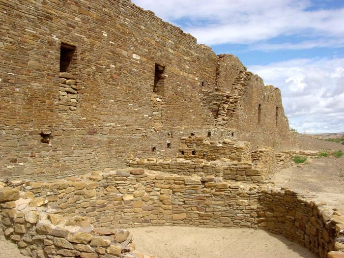
Pueblo del Arroyo at Chaco Canyon, New Mexico, by the National Park Service
Drought caused the collapse of the Ancestral Puebloan culture at Chaco Canyon and throughout the Four Corners region around 1130 AD. This environmental crisis prompted a mass migration of the Ancestral Puebloans to the Rio Grande and other more fertile valleys in the Southwest, where they began to compete with other indigenous communities, such as the Apache, for territory in the Rio Grande Valley. This competition led to decades of conflict, ultimately resulting in the merging of cultures and the establishment of many of the Tanoan and Keresan pueblos in the Rio Grande Valley.
The significant prehistoric increase in settlement in the Rio Grande area occurred between approximately 1200 and 1400 A.D. These dates follow the collapse of the structured social system centered in Chaco Canyon and the abandonment of large areas of the Colorado Plateau. Some people from the San Juan Basin and Mesa Verde areas may have moved into the upper Chama and Rio Grande Valleys, contributing to the population increase.
Following this period, the Classic Period occurred from about 1325 A.D. to 1600 A.D., coinciding with the arrival of the Spanish.
In 1519, a Spanish naval expedition along the northeastern coast of Mexico charted the mouths of several rivers, including the Rio Grande.
In 1536, the Rio Grande first appeared on a map of New Spain, produced by a royal Spanish cartographer. In the autumn of 1540, a military expedition led by Francisco Vásquez de Coronado, Governor of Nueva Galicia, and part of the Viceroyalty of New Spain, reached the Tiwa pueblos along the Rio Grande in what is now New Mexico.
There were 61 pueblos known to have been abandoned by 1540. Although reasons other than epidemic disease are given for some of these abandonments, disease is an all-too-common factor in most cases. Heavy population losses must have had profound effects on the pueblo’s economy and political organization.

Jemez State Monument – Gisewatowa Pueblo Church Ruins by Kathy Alexander.
Villages that could not continue to survive socially may have merged with other villages, as the inhabitants of Pecos did when they relocated to Jemez in the 19th Century. Wild-plant and animal foods were not only crucial to the pueblos prehistorically, but often may have made the difference between starvation and survival. European domestic livestock grazed on land that had provided the wild resources essential to the pueblos.
On July 12, 1598, Don Juan de Oñate y Salazar established the New Spain colony of Santa Fe de Nuevo Méjico at the new village of San Juan de los Caballeros adjacent to the Ohkay Owingeh Pueblo at the confluence of the Rio Grande and the Río Chama.
The upper Rio Grande Valley frequently experienced extreme droughts, prompting the inhabitants to develop extensive, gridded gardens and check dams to maximize their limited water supply. During this period, there was significant population instability, characterized by the abandonment of many large Rio Grande pueblos and the establishment of new ones. A century later, during the initial phase of Spanish occupation in the Rio Grande, the Pueblo population saw a dramatic decline of 90-95%, dropping from 60,000 individuals in 1600 A.D. to under 6,500 by 1706 A.D. This population decline is primarily attributed to a combination of European diseases, famine, and warfare.
In the 17th century, the Rio Grande Valley became a migration corridor for Spanish settlers, who were probing deeper into New Mexico from the mining towns of Chihuahua. In 1680, it became a refuge for the descendants of immigrants fleeing the aftermath of the Pueblo Revolt.

Pueblo pottery maker.
Both prehistoric and modern Pueblo villages consist of a series of interconnected room blocks, along with one or more open community plaza areas and semi-subterranean ceremonial rooms known as kivas. The cotton dresses, kilts, sashes, and headdresses worn by dancers during ceremonies are depicted in rock art and murals dating back to the 14th century. Many symbolic representations found on late prehistoric ceramics, rock art, and kiva murals are still recognized and understood by contemporary Pueblo people. These symbols include plumed serpents, kiva stairs, and lightning, as well as depictions of specific ceremonies and cosmological figures.
On a practical level, modern Pueblo women create pottery, grind corn using manos and metates, and utilize various wild plants found in archaeological contexts. Similarly, modern Pueblo men possess knowledge of hunting and farming rituals, the organization of ceremonial events, and the education of young men for leadership roles in Pueblo society. Most importantly, Pueblo Indians continue to speak their native languages and uphold their traditions.
There are key differences between the late prehistoric and historic periods that suggest distinct organizational patterns. The similarities in ceramic styles and kiva art between the Rio Grande and Western Pueblo cultures indicate significant interaction, despite the distance from Pecos to the Hopi villages.
These artistic motifs may relate to Kachina religious practices, potentially originating in the Jornada and Rio Grande areas before spreading to the Western Pueblos. Importantly, this reflects a level of interaction among villages that is not well-documented historically. Additionally, evidence shows that late prehistoric villages may not have been entirely autonomous, as some larger sites lack kivas while others in the same cluster have several.

Abo Mission and Kiva by the National Park Service.
Similarities in ceramic styles and kiva art between the Rio Grande and Western Pueblos suggest significant interactions, despite their distances. Some motifs may be linked to the Kachina cult, possibly introduced from the Jornada and Rio Grande regions. Additionally, evidence shows that late prehistoric villages may not have been entirely autonomous. Within clusters of contemporary sites, some larger locations lack kivas, while others have multiple kivas. Modern pueblos continue to maintain shrines and sacred areas that extend beyond their reservation boundaries, sometimes overlapping onto other reservations.
Modern pueblos have shrines and sacred sites that extend beyond their reservation boundaries, sometimes onto other reservations. For example, the Zuni people maintain shrines in the Sandia Mountains, and the Hopi journey to the Zuni Salt Lake. Differences between late prehistoric and historic periods indicate that the organizational structures of prehistoric societies were distinct from those of today.
The Rio Grande was a busy navigation route in the 19th century, with over 200 steamboats operating between Brownsville and Rio Grande City, Texas.
In the late 1830s and early 1840s, the river marked the contested border between Mexico and the Republic of Texas, contributing to the Mexican-American War in 1846 after Texas became a state. This corridor facilitated trade, migration, and communication, thereby increasing U.S. political influence. During the war, many steamboats from the Ohio and Mississippi Rivers were redirected to support the U.S. Army as it advanced toward Monterrey, Nuevo León. Engineers noted that the river could be made navigable to El Paso, but the recommendations were never acted upon.
Since 1848, the Rio Grande has defined the boundary between Mexico and the United States from El Paso and Ciudad Juárez to the Gulf of Mexico. It also served as an escape route for some enslaved Texans seeking freedom, as Mexico abolished slavery in 1828.
A severe smallpox epidemic struck the First Mesa Hopi villages as late as 1853, reducing the population from 1200 to 650 people by 1862.

Bagdad, Tamaulipas Commercial Port.
At the mouth of the Rio Grande, on the Mexican side, was the large commercial port of Bagdad, Tamaulipas. During the Civil War, this was the only legitimate port of the Confederacy. European warships anchored offshore to maintain the port’s neutrality and successfully managed to do so throughout the conflict, despite occasional stare-downs with blockading ships from the U.S. Navy. It was a shallow-draft river port, with several smaller vessels that hauled cargo to and from the deeper-draft cargo ships anchored offshore. These deeper-draft ships could not cross the shallow sandbar at the mouth of the river. The port’s commerce consisted of European military supplies in exchange for bales of cotton.
In 1899, following a gradual shift in the river’s position, a channel was dug for flood control, which in turn altered the river’s course, creating what was later known as Cordova Island. This development became the center of the Chamizal Dispute, a land and boundary conflict. Resolving the dispute took many years and resulted in a combined assassination attempt on the American and Mexican presidents in 1909.

Elephant Butte Dam, New Mexico.
Following the approval of the Rio Grande Project by federal lawmakers in 1905, the waters of the Rio Grande were to be divided between the states of New Mexico and Texas based on their respective amounts of irrigable land. The project also accorded 60,000 acre-feet of water annually to Mexico in response to the country’s demands. This was intended to resolve the long-standing disagreement over the rights to the river’s flow and the construction of a dam and reservoir at various locations along the river between the agricultural interests of the Mesilla Valley and those of El Paso and Juárez. In the agreement, provisions were made for the construction of the Elephant Butte Dam on public lands. This act was the first instance of a congressionally directed allocation of an interstate river.
Recognizing water challenges, in 1938, Colorado, New Mexico, and Texas came together to develop the Rio Grande Compact. The Compact requires a proportion of the annual river flow to be delivered downstream from Colorado to New Mexico and Texas, an amount that varies based on a complex set of factors and the total available water in the system. Water users across the Basin must adhere to and comply with Compact obligations. The compact remains in effect today, though it has been amended twice.
In 1944, the U.S. and Mexico signed a treaty regarding the river.
Since the mid–20th century, only 20% of the Rio Grande’s water reaches the Gulf of Mexico due to the substantial water consumption required for irrigating farmland and hydrating cities, as well as the water retained by diversion dams.

Rio Grande Wild & Scenic River in Texas by the National Park Service.
In 1978, Congress designated a 196-mile portion of the Rio Grande as part of the National Wild and Scenic Rivers System.
In 1997, the U.S. designated the Rio Grande as one of the American Heritage Rivers. Two portions of the Rio Grande are designated as part of the National Wild and Scenic Rivers System, one in northern New Mexico and the other in Texas, at Big Bend National Park.
In mid-2001, a 328-foot-wide sandbar formed at the mouth of the river, marking the first time in recorded history that the Rio Grande failed to empty into the Gulf of Mexico. The sandbar was dredged, but reformed almost immediately. The spring rains of the following year flushed the reformed sandbar out to sea, but it returned in mid-2002. By late 2003, the river once again reached the Gulf.
For much of the time since water rights were introduced in the 1890s, the Rio Grande has flowed through Las Cruces from February to October each year; however, this is subject to change due to climate variability. In 2020, the river flowed only from March to September. In January 2021, the Elephant Butte Irrigation District anticipated that water shortages would result in the river only flowing through Las Cruces from June to July. The water shortages affect the local ecosystem and endanger species, including cottonwood trees and the southwestern willow flycatcher.
In 2022, due to increasing drought and water use, the water debt owed to Texas increased from 31,000 acre-feet to over 130,000 acre-feet since 2021, despite “very significant efforts that were made on the river this year to keep water flowing downstream.” In response, New Mexico increased its program offerings to subsidize farmers who fallow their fields rather than planting crops, which uses additional water.

Rio Grande in Big Bend National Park, May 2022, by Dylan Baddour, Inside Climate News.
In late July 2022, due to an extreme drought, the Rio Grande ran dry for approximately 50 miles in the middle of the Rio Grande Valley, including five miles in Albuquerque, marking the first time it had done so in over 40 years. The following winter, the basin experienced above-average snowfall, resulting in very high flows in the river during the spring of 2023 and flooding of some of its tributaries, including the Jemez and Pecos Rivers. By that summer, after the spring runoff had concluded and due to a failed New Mexico monsoon season and record high temperatures, the river went dry in Albuquerque for a second consecutive year.
Elephant Butte Reservoir, the primary storage reservoir on the Rio Grande, was reported to be 13.1% full as of May 1, 2022, and further decreased to 5.9% full by November 2022. Nearly a year later, in October 2022, the reservoir had made only insignificant rebounds, resting at 6.4% of capacity.
Today, the water of the Rio Grande is over-appropriated, meaning there are more users for the water than there is water in the river. Due to both drought and overuse, the section from Las Cruces downstream through Ojinaga frequently runs dry and was recently dubbed “The Forgotten River” by those seeking to draw attention to the river’s deteriorating condition.
Although the river’s greatest depth is 60 feet, the Rio Grande generally cannot be navigated by passenger riverboats or by cargo barges. Navigation is only possible near the mouth of the river, in rare circumstances up to Laredo, Texas.

Taos Pueblo, New Mexico. Kathy Alexander.
The river historically supported more than 100 pueblos in the Rio Grande Valley. The pueblos, as well as Spanish and European settlers, used the fertile soil in the Rio’s floodplain to farm along its banks. A network of irrigation canals, extending from southern Colorado to northern New Mexico, was constructed to serve the irrigation needs of local communities. Today, the river sustains 20 pueblos and tribes from New Mexico to Texas. The community irrigation system in northern New Mexico remains in place and is protected by state law.
The Rio Grande also supports tourism and recreation economies. Protected landscapes along the main stem of the river include the Rio Grande del Norte National Monument and Valle del Oro and Bosque del Apache National Wildlife Refuges in New Mexico, and the Big Bend National Park, the Santa Ana, Laguna Acosta, and the Lower Rio Grande National Wildlife Refuges in Texas. Three additional protected regions exist south of the Big Bend region in Mexico, including Cañon de Santa Elena, Ocampo, and Maderas del Carmen Flora and Fauna Protection Areas.

Bluffs Above the Rio Grande in Big Bend National Park in Texas by Carol Highsmith.
©Kathy Alexander/Legends of America, updated August 2025.
Sources:
American Rivers
National Park Service
New Mexico Geological Society Guidebook, 35th Field Conference. Rio Grande Rift: Nonhem, NM, 1984.
Rio Grande Prehistory; Department of Anthropology, University of New Mexico. Albuquerque, N.M.
Wikipedia
Wild Earth Guardians