
Alpine Loop Back Country Byway Map.
Tucked away in the San Juan Mountains of southwestern Colorado is the Alpine Loop National Backcountry Byway. Located northeast of Silverton, Colorado, in San Juan and Hinsdale Counties, the circular route from Lake City south along CO-149 to County Road 30, which turns west over Cinnamon Pass to Animas Forks. Then, it returns east over Engineer Pass to Lake City along County Road 20.

Alpine Loop Backcountry Byway, Colorado.
Sculpted by the forces of volcanoes, glaciers, wind, and rain, the resulting mountains, valleys, streams, and lakes are a masterpiece of nature’s artistry. The Ute Indian tribe long inhabited this area before they were replaced by miners in the 1800s, who came in search of silver, gold, lead, and zinc. These hardy pioneers carved a network of roads through this rugged terrain to transport ore and supplies by mule-drawn wagons to and from Silverton, Ouray, and Lake City.
The mines and mills are closed today, but the roads remain. Many still visible exploration pits and tunnels give evidence of extensive prospecting. The Hidden Treasure, Ute-Ulay, Golden Fleece, Little Giant, and Pride of the West mines are only a few of the more than 70 mines with lodes that beckoned 19th-century entrepreneurs. Many mining towns, such as Animas Forks, Mineral Point, and Capitol City, boomed when the railroad brought mobility and transportation to Lake City. Now, only the skeletons of these ghost towns remain.
This system of historic roads is now the Alpine Loop National Backcountry Byway. Part of the National Scenic Byway system, the Alpine Loop was one of the Bureau of Land Management’s first backcountry byways. Unlike most scenic byways on paved highways, backcountry byways focus on the out-of-the-way sights on gravel and dirt roads. These routes are unsuitable for all vehicles; however, backcountry byways offer views of various areas off the beaten track for those with appropriate transportation.

Alpine Loop over Engineer Pass, by Bob Kane, Google Maps.
The backcountry byway covers 65 miles of roads between Lake City, Ouray, and Silverton, Colorado. Depending on winter snow, the Loop opens in late May/early June and closes in late October. Today, visitors can follow the routes used by the prospectors, miners, and settlers who ventured into the mountains to seek their fortune. Portions of this road are not paved and require a four-wheel drive, high-clearance vehicle. The Alpine Loop has narrow twists and blind curves.
In addition to the outstanding scenery, visitors enjoy various outdoor recreation activities. The rivers, streams, and lakes attract fishermen and hikers who can access the many trails up to five peaks over 14,000 feet.
History buffs will want to explore the many structures, mines, and ghost towns left over from the late 1800s. Photographers will especially appreciate the abundance of colorful alpine wildflowers in late July/early August and the explosion of fall colors during September.
The Alpine Loop has rustic facilities, including three campgrounds, a picnic area, and ten restrooms. Its driving time is estimated at 4-6 hours. The loop can be accessed from Lake City, Silverton, or Ouray.
The Alpine Loop is truly a backcountry experience. Make sure someone knows your travel plans and do your homework before you start your trip. Ensure you have plenty of water, food, and fuel to reach your destination. Electronics and wireless devices DO NOT work in most places on the Alpine Loop. You should download or print hard-copy maps before your trip.
The main loop is only part of the experience, as miles of designated side routes allow visitors to access several other sites.
Courtesy Rules of the Alpine Loop

Alpine Loop Sally Pearce, Colorado Department of Transportation.
- Stay on designated roads.
- Obey posted signs for parking and trails.
- Please drive slowly and watch for on-coming traffic.
- Stay on your side of the road on blind curves. Honk to warn on-coming traffic.
- Uphill traffic has the right-of-way.
- Do not park or stop on narrow sections of the road. Use pull-outs or wider areas of the road to park.
- Most traffic moves clockwise, and it is highly suggested that you do so. This helps with traffic jams on the narrow shelf sections of this route.
Sites along the Main Alpine Loop:

Animas Forks, Colorado by Adam Baker, Wikipedia.
Animas Forks – This town was established in 1875 and was occupied until the 1920s. Retaining several historic buildings, it is one of the most popular destinations along the Alpine Loop National Backcountry Byway. This was once a bustling community with numerous buildings and mill sites. Today, it displays nine buildings, including the two-story Duncan House, the Columbus Mill, and the jail structure, the oldest building on the site. Foundations and other falling buildings dot the area. Interpretive signs tell the history of the town. The Alpine Loop Road continues north along County Road 2 to Engineer Pass.
On the other hand, San Juan County Road 2 makes its way southwest to Silverton. (See Silverton Road.) A side spur of the Alpine Loop, Co Rd 9, leads west of Animas Forks, making a loop around Treasure Mountain back to Co Rd 2. See Side Spur – County Road 9. Several mines and mills can be seen along this loop, including the well-preserved Sound Democrat Mill
.Mineral Point – From Animas Forks, San Juan County Road 2 makes its way upward to Engineer Pass. The trail comes to a crossroads 2.7 miles north of Animas Forks, with Co Rd 17 making its way to the left. About a mile to the west, mining remains can be seen in the valley below, and there are several dirt trails into the valley. Mineral Point thrived from the 1870s through the 1890s. Co Rd 17 continues to the northwest, turning into Ouray County Road 18, before connecting with Highway 550 and north to Ouray. This road can be difficult, and some portions are recommended only for expert 4×4 drivers. Return east on Co Rd 17 and north onto Co Road 2 to continue the Alpine Loop Tour.
Engineer Pass – Located 2.3 miles north of the intersection of Co Rd 17 and Co Rd 2, the trail reaches the summit of Engineer Pass. Sitting at an elevation of 12,800 feet, the views are spectacular. To the west is Mt. Sneffels at 14,150 feet, to the northeast is Uncompahgre Peak and at 14,309 feet, and to the east is the extinct Lake City volcanic caldera, which the Loop Road encircles. Otto Mears built the first toll road over Engineer Pass, completed in 1877. The road became a major route connecting Silverton, Animas Forks, Ouray, and Lake City. As the Alpine Loop Trail crosses the pass, it enters San Juan County and becomes Hinsdale County Road 20.

Palmetto Gulch Mine on the Alpine Loop Backcountry Byway by Extreme Geographer.
Galena Mining District – Beyond Engineer Pass is the Galena Mining District, which stretches east from the Ouray-San Juan county line for 16 miles to Lake City. The Frank Hough Mine was situated near the top of Engineer Pass’s east side, approximately 500 feet from the Alpine Loop Trail. Along with the nearby Palmetto Mine and Mill, it was owned by John S. Hough, a good friend of Kit Carson who ran for Colorado governor in 1880. The most significant activity of these mines occurred in the early 1880s. A mining camp called Engineer City also once stood here. It was established in 1881 around the Frank Hough Mine. All that is left today of these mining operations is a portion of the Palmetto Gulch Powderhouse and scattered debris. The Empire Chief Mine, mill, and boarding house were further down the road. The mine was initially discovered in 1885 and operated intermittently until 1930. It was stabilized in 2000, but unfortunately, it was destroyed by an avalanche in 2008. Today, its fallen timbers can still be seen along the mountainside.
Rose’s Cabin – About three miles east of Engineer Pass’s summit is a sign for Rose’s Cabin. The initial cabin was built in 1874 by Corydon Rose and grew into a saloon, hotel, stable, store, and post office. A mining camp was also established here that had about 50 people. Everyone was gone by 1900. Today, all that is left are the timbers of an old building and an old safe sitting in the meadow.

Golconda Mine Boarding House, courtesy of HistoriCorps.
Golconda Mine – Beyond Rose’s cabin, travelers come to the intersection of Co Rd 20 and Co Rd 21. The latter runs across Henson Creek for 1.5 miles to the old Golconda Mine. The mining complex consists of the century-old Golconda Boarding House and Compressor House. Stabilized in 2015, the boarding house is the largest remaining standing log structure on the east side of the Alpine Loop that is accessible to the public. The compressor building is located southeast of the boarding house and still contains intact machinery that is distinct from hard rock mining.
Rose Lime Kiln – On Hinsdale County Road 20, travelers will soon come to Rose’s Lime Kiln. George S. Lee, who owned the Lee Mining & Smelting company at Capitol City, built it. Standing 44 feet tall, it once produced an ash-free lime used as a cement additive. The kiln was named after Rose Lee, the daughter of George and Mary Jane Lee. It is listed in the National Register of Historic Places.

Whitmore Falls near Lake City, Colorado, by Parkerpics.
Whitmore Falls – Located just about ten miles west of Lake City, Whitmore Falls is near the trail. It is marked by a wooden sign reading: “Whitmore Falls Scenic Overlook.” It is a short downhill walk to the observation point and well worth it for a sensational photo opportunity.
Capitol City – Just two miles beyond the waterfall, the trail comes to the old mining camp of Capitol City. The town was founded in 1877 by George Lee, who believed his town was ideal and that it would become the capital of Colorado. Early on, the mining camp thrived, boasting several hotels, restaurants, saloons, smelters, a sawmill, a post office, a schoolhouse, several houses, and a population of 400. However, when the price of silver dropped in the 1890s, the mine and the town began to decline. Its post office closed in 1920. Today, only the post office and a few other log buildings remain.
Pike Snowden Cabin – About 3.5 miles east of Capitol City is the Pike Snowden Cabin site. Pike Snowden built the cabin near Henson and Nellie Creeks’ confluence in the late 1870s. Snowden, a colorful character in local lore, lived here until about 1915 while exploring for lead and silver in the surrounding mountains. The bars on the windows are remnants of Snowden’s fear of being shot in his sleep after winning a large sum in a poker game in Creede, Colorado.
Henson and the Ute-Ulay Mines – About a mile and a half beyond the Snowden Cabin, the trail leads to Henson’s old mining town. This was a rough and tumble town when the Ute-Ulay mine operated between 1874 and 1903. At one point, the mine was one of Colorado’s best-known silver and lead producers and was primarily responsible for Lake City’s development. The mines continued to produce on and off through the 1980s. Nothing is left of the old townsite, but numerous buildings are associated with the mines. The Ute-Ulay Mine and Mill site are listed in the National Register of Historic Places.

Ute-Ulay Mine near Lake City, Colorado, courtesy of Historicorps.
Hard Tack Mine—About a mile east of Henson is the Hard Tack Mine. There was once a town called Treasure City that operated from the 1890s until 1930, supported by the Hidden Treasure and Hard Tack Mines. Today, the Hard Tack Mine and Museum offers daily tours between June and September. The road continues to nearby Lake City.

Lake City, Colorado.
Lake City – The county seat of Hinsdale County, Lake City, started after rich mineral deposits were discovered in the area. It quickly became a supply center for the prospectors and miners and was incorporated in 1873. The town boomed in 1874 after discovering the Golden Fleece Mine south of the community. In its early days, the town boomed and boasted as many as 3,000 people. Today, a quiet community of about 375 people primarily caters to the many tourists for a wide range of outdoor recreation opportunities. From Lake City, follow CO-149/Gunnison Ave for 2.5 miles and turn right onto County Road 30, the Alpine Loop route.
Lakeshore & the Golden Fleece Mine – The Golden Fleece Mine was located in the San Juan Mountains about four miles south of Lake City, Colorado, and half a mile west of the north end of Lake San Cristobal. The mining camp of Lakeshore was located at the lake’s north end. Today, several summer cabins occupy the area where the camp once stood. Tailings can be seen on the mountain slopes west of the lake.

Lake San Cristobal, Colorado, courtesy Wikipedia.
Lake San Cristobal – Located about 3.5 miles south of Lake City, this natural lake was formed about 700 years ago when a natural earthflow called the Slumgullion Slide created a dam across the Lake Fork of the Gunnison River. It is the second-largest natural lake in Colorado, over two miles long. The lake provides fishing, boating, camping, and wildlife viewing for visitors.

Carson, Colorado by Mike Sinnwell, Rocky Mountain Profiles.
Wager Gulch-Carson Ghost Town – About 5.5 miles beyond Lake San Cristobal’s road, it comes to Wager Gulch. Here, the Alpine Loop intersects with County Road 36, which heads south for about five miles to Carson’s ghostCarson’she five-mile stretch up Wager Gulch is a rough road that requires a high-clearance, 4-wheel drive vehicle. It actually to the remnants of two old mining camps – Carson and Old Carson. Carson is remarkably well-preserved, with several old buildings. As visitors continue west, Red Mountain rises into view as the byway climbs toward Sherman’s; keep an eye out for bighorn sheep, often seen along the rocks in the area.
Sherman Mining Camp – The old mining camp of Sherman is about 4.4 miles west of Wager Gulch. The mining camp was active from the late 1870s through the 1910s but was never very big. There is very little left of the old camp today, but foundations, the remains of collapsed log cabins, and some old equipment. The townsite is located on private property. To get there from Wager Gulch, continue on County Rd 30 for three miles, then take a slight left onto County Rd 35 for 1.4 miles to the old townsite. Alternatively, continue past Co Rd 35 to an overlook on Co Rd 30 that provides a birdseye view of the old townsite.
Burrows Park – About four miles beyond Sherman is Burrows Park. Located along the Hinsdale-San Juan County line, Burrows Park is a five-mile-long grassy meadow area that once encompassed several mining camps, including Burrows Park, Whitecross, Tellurium, Argentum, and Sterling. Little remains of these old camps today except two cabins restored by the forest service. This is the starting point for hikes to several nearby fourteeners. In the mountains are traces of foundations and the remains of fallen buildings.

American Basin, Colorado, courtesy of the U.S. Forestry Service.
American Basin – Just a few miles beyond Burrows Park is the American Basin. Part of the Gunnison National Forest, it is a high alpine basin at an elevation of 12,365 feet surrounded by vertical cliffs. It is well-known for its spectacular scenery and beautiful displays of alpine wildflowers.
Tobasco Mine & Mill – Continue on County Road 30 for about half a mile to a spur to the right that makes its way for 0.3 miles to the Tobasco Cabin. This is the last standing structure of the old Tobasco Mine and Mill property. Farther up the mountain are the scattered remains of collapsed buildings, foundations, and the mill itself, which is completely collapsed. Several tram towers can also be seen.
Cinnamon Pass – The trail continues along Cinnamon Pass for 1.7 miles before reaching the summit. Cinnamon Pass is among the highest in the San Juan Mountains, at 12,620 feet. The summit provides breathtaking views of the alpine tundra and the high mountain peaks of Handies, Redcloud, and Sunshine, three of the fourteeners in the area. At the summit of Cinnamon Pass, the trail continues westward, leaving Hinsdale County behind and entering San Juan County. The road then becomes San Juan County Road 5 and continues for 2.8 miles to Animas Forks.
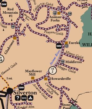
Silverton to the Alpine Loop, Colorado map.
Silverton to the Alpine Loop
From Greene Street (Highway 110), the main road through Silverton, turn east onto Blair Street, which becomes County Road 2. This road makes its way northeast through several interesting sites before it arrives at Animas Forks 12 miles later.
Silverton – Established in 1874, Silverton quickly became the center of numerous mining camps and stole the county seat from Howardsville. Today, Silverton is home to about 630 people. The town’s rich history, stunning natural beauty, and ample recreation opportunities draw thousands of visitors each year.
Arrastra Gulch – From Silverton, follow County Road 2 for two miles to Co Rd 52, right off County Road 2, just before the Mayflower Mill. Co Rd 52 makes its way southeast into Arrastra Gulch, gradually deteriorating along the 2.6-mile trek to the Mayflower Mine. A trailhead climbs 1,050 feet over 1.3 miles to Silver Lake and the Silver Lake Mine. Silver Lake is listed in the Guinness Book of Records for its record snowfall of 76 inches in 24 hours in April 1921. Return to Co Rd 2 to continue to the Alpine Loop.
Mayflower Mill – Just beyond Arrastra Gulch, the Mayflower Mill sits on the north side of Co Rd 52. A National Historic Landmark, it was the last and the most advanced of the big mills to be built in the San Juan Mountains. The San Juan Historical Society provides tours of the mill in the summer.

Mayflower Mill near Silverton, Colorado, Historic American Building Survey.
Side Spur – Co Rd 4 – Two miles beyond the Mayflower Mill is a side spur on Co Rd 4 that will take travelers to the Old Hundred Mine and the Highland Mary Mine.

Old Hundred Mine Boarding House by the San Juan County Historical Society.
Old Hundred Mine – One-mile southeast of Co Rd 2, along the side spur of Co Rd 4, is the Old Hundred Mine. A German named Reinhard Niegold was one of the earliest prospectors to find rich ore on Galena Mountain in 1873. The Old Hundred Mining Company was organized in 1904, and mining occurred sporadically until 1972. Today, the mine can be explored in the summer on a tour that takes visitors 1/3-mile into Galena Mountain.
Highland Mary Mine – This mine is located 5.4 miles south of the Old Hundred Mine on County Road 4, a side spur of the Co Rd 2. Minerals were first discovered here in 1875 by the Ennis brothers. Failing to make a profit, the brothers declared bankruptcy in 1985. In 1907, new owners reopened the mine, which became the second-largest operation in the Silverton area. There are remnants of the old mill today. The Highland Mary Lakes Trailhead is located here to connect with Whitehead Peak Trail and leads south into the Weminuche Wilderness. Return to Co Rd 2 to continue north to the Alpine Loop.

Howardsville, Colorado, in its heydays.
Howardsville – Just a half-mile northeast of the side spur is the old mining camp of Howardsville. Established at Cunningham Gulch’s mouth iGulch’s, it became one of the area’s largest and most prosperous towns. It was the first Sunnyside Mill site and, in its earliest days, was the county seat of La Plata County before the county was divided up and San Juan County was established in 1876. Today, there are several old buildings at the townsite.
Middleton – Located just 1.6 miles beyond Howardsville, the town of Middleton once stood. This community was named because it was in the middle between Howardsville and Eureka. The first claim was made in 1883, and before long, there were over 100 mining claims in the nearby Minnie and Maggie Gulches. Nothing remains of the townsite today, but mining remains can be seen in the area.
Eureka – Just 1.2 miles north of Middleton is the old mining camp of Eureka. Prospecting here dates back to 1860, but the town wasn’t laid out until 1874. The community was primarily supported by the nearby Sunnyside Mine and Mill, located about four miles to the northwest. All that remains of the town today is one small building.

Remains of the Sunnyside Mill at Eureka, Colorado, courtesy Wikipedia.
Sunnyside Mine – Continue north on Co Rd 2 for about 0.7 miles to County Road 25, making a sharp left to the southwest. Continue on this road for 3.5 miles to the Sunnyside Mine and Lake Emma. The Sunnyside Mine was first located in 1873 and produced rich gold ore in its early years. The mine changed hands many times but remained in production until 1938. In the 1960s, it reopened after completing the 6,233-foot American Tunnel through Bonita Peak to the mining camp of Gladstone. However, in 1978, the bottom of Lake Emma broke through and flooded the mine. It was later reopened and operated intermittently until 1999. Return to County Road 2 to continue to Animas Forks.
Alternate Routes to Animas Forks – From County Road 25, which leads to the Sunnyside Mine, Animas Forks can be reached quickly by traveling just 3.8 miles north along Co Rd 2. However, another route makes the trek via County Road 9, situated 2.4 miles north of the road to the Sunnyside Mine.

County Road 9 Map.
Side Spur – County Road 9 – This side spur is 3.2 miles north of Eureka or 2.4 miles north of County Road 25, the road to the Sunnyside Mine. Look for a sign reading “Picayune Gulch.” Though this r”ute is longer, it is far more interesting as it travels along the face of Treasure Mountain and then almost to the top of Hanson Peak. This route makes a loop around Treasure Mountain for 7.5 miles and approaches Animas Forks from the west. Along the way are Treasure Mine’s sites, the Democrat Mine and Mill, the Gold Prince Mine, and the skeletal remains of the Frisco-Bagley Mill and Tunnel. This route can also be traveled in the opposite direction from Animas Forks.
Treasure Mountain Mine – County Road 9 makes a sharp turn back south of County Road 2 and makes its way about west to the Treasure Mountain Mine. In 1881, investors founded the Treasure Mountain Mining & Milling Company in Chicago, Illinois. Several structures, including a bunkhouse, blacksmith shop, and stamp mill, are located on the south side of the trail. Treasure Mountain gained its name from a local legend of hidden treasure.

Placer Gulch, Colorado, courtesy 4×4 Explore.
Placer Gulch – The trail climbs westward out of Picayune Gulch to a high summit dividing Picayune Gulch from Placer Gulch. Here is a parking area overlooking fantastic views from all directions. The road descends into a natural bowl surrounded by Treasure Mountain, California Mountain, Houghton Peak, and Hanson Peak. Here are the ruins of several mines and mills, most notably the Sound Democrat Mill, which sits on a slope on the south bank of Placer Gulch. The collapsed Mastodon Mill is 300 feet to the north on the opposite bank of Placer Gulch, and the ruins of the Hanson or Sunnyside Extension mill are approximately one-half mile to the west at the head of Placer Creek and near the Gold Prince Mine. The ruins of the Gold Prince surface works are one-half mile distant, and the tramway system from the mine to the mill in Animas Forks, approximately 12,000 feet in length, has standing towers and remnants of support structures.

Sound Democrat Mill, courtesy of Starbuck’s Exploring.
Sound Democrat Mill – A short spur off the main road leads to the well-preserved Sound Democrat Mill, built in 1905 and operated until 1914. Powered by electricity, the mill processed ore from the Sound Democrat and Silver Queen mines located on Treasure Mountain’s east. The complex consisted of the two mines, an aerial tramway that transported the ore to the mill, and a surface railway connecting the Silver Queen to the Sound Democrat’s ADemocrat’sway. Today, only the mill stands intact, stabilized by the Bureau of Land Management. There are interpretive signs at the complex. Return to County Road 9 and continue north to Animas Forks. The old tramway towers from the Gold Prince Mine to the mill in Animas Forks can still be seen along the way.
Frisco-Bagley Mill and Tunnel – Co Rd 9 continues north for several miles before it turns right (east) to the Frisco Mill and Bagley Tunnel in California Gulch. Built in 1912, this complex featured several buildings, including a boarding house, compressor house, mine manager’s home, manager’s shop, and tool shed. Today, the site includes the partially collapsed 150-ton reduction mill, cement foundations that once anchored compressors, and the Bagley Tunnel opening approximately 200 feet away from the mill. The portal to the tunnel is now blocked off, and a stream flows out of it. From here, the road goes about half a mile to Animas Forks.

Alpine Loop and side spurs.
Contact Information:
For the southern parts of the loop:
BLM – San Juan Public Lands Office
15 Burnett Court
Durango, Colorado 81301
970-247-4874
For the northern parts of the loop:
BLM – Gunnison Field Office
216 North Colorado Street
Gunnison, Colorado 81230
970-641-0471

Alpine Loop, Colorado by Dennis Adams.
©Kathy Alexander/Legends of America, updated January 2025.
Also See:
Early Mining and Transportation in Southwestern Colorado
Sources:
Bureau of Land Management
Colorado Department of Transportation
Lake City, Colorado
U.S. Forest Service